The 9 Best Navigation Apps for Android & iOS in 2026
A comprehensive guide to the best navigation and GPS apps for Android and iOS in 2026 — including Google Maps, Waze, Apple Maps, Sygic, and more — plus when to use dedicated route optimization software for deliveries.
Navigation apps have become indispensable tools for anyone who drives — and for delivery businesses, they're a critical part of daily operations. In 2026, the best navigation apps go far beyond basic turn-by-turn directions. They integrate AI-powered routing, real-time community traffic data, augmented reality overlays, and offline maps that work even when your signal doesn't.
Whether you're a delivery driver navigating a 30-stop route, a field service technician covering a rural territory, or a business owner looking for the right tools for your team, this guide breaks down the best navigation apps available for Android and iOS in 2026 — and explains where dedicated route optimization software picks up where general navigation apps leave off.
Table of Contents
What Makes a Great Navigation App in 2026?
The Best Navigation Apps for Android & iOS
Quick Comparison Table
Navigation Apps vs. Route Optimization Software
Frequently Asked Questions
Conclusion
What Makes a Great Navigation App in 2026?
Before diving into individual apps, it's worth understanding the features that separate a good navigation app from a great one in 2026:
AI-powered routing: The biggest shift this year is artificial intelligence moving from a buzzword to a genuinely useful navigation feature. Google Maps now uses its Gemini AI model to understand natural language queries, and several apps are beginning to offer predictive routing that anticipates congestion before it develops. Expect this to become standard across major platforms.
Real-time community data: Official traffic sensors only tell part of the story. The best apps in 2026 supplement sensor data with real-time reports from other drivers — speed traps, accidents, road closures, and hazards reported seconds ago by someone just ahead of you on the road.
Offline capabilities: Signal dropouts still happen, especially in rural delivery areas, underground parking, or when traveling internationally. The top apps let you download detailed maps for entire regions, so your GPS keeps working even without a data connection.
Augmented Reality (AR) navigation: Both Google and Apple are pushing AR walking directions heavily in 2026. You hold up your phone and see directional arrows overlaid on the real-world street view. For drivers, head-up display (HUD) modes that project directions onto your windshield are becoming more common.
Multi-modal support: The best apps handle driving, cycling, walking, and public transit routing — useful for businesses with drivers who may need to navigate on foot for the final stretch of a delivery.
The Best Navigation Apps for Android & iOS
1. Google Maps
Best for: All-around reliability | Price: Free | Platforms: iOS, Android, Web
Google Maps remains the most widely used navigation app in the world, and for good reason. It's rarely the absolute best at any single feature, but it's consistently strong across the board — real-time traffic, accurate routing, comprehensive business data, and support for driving, cycling, walking, and public transit.
The standout update for 2026 is the integration of Gemini AI, which lets you search using natural language instead of keywords. Instead of typing "Italian restaurant," you can ask "quiet place with good pasta that's open now and has parking" and get a genuinely useful answer drawn from reviews, hours, and live data. The Immersive View feature has also improved significantly, using computer vision to create 3D previews of your route — helpful for spotting tricky parking garage entrances or unfamiliar intersections before you arrive.
For delivery use, Google Maps offers multi-destination routing for up to 10 stops, real-time traffic rerouting, and a massive database of addresses. Its limitation is that it doesn't optimize stop order — it routes your stops in the sequence you enter them. For anything beyond a handful of deliveries, you'll need dedicated route optimization software alongside Google Maps.
2. Waze
Best for: Avoiding traffic in real time | Price: Free | Platforms: iOS, Android
Waze is the community-driven navigation app that excels at one thing above all others: getting you through traffic as fast as possible. Because it relies on real-time, crowd-sourced reports from millions of active users, Waze knows about accidents, speed traps, road closures, and police activity faster than any sensor-based system.
In 2026, Waze's live updates have become even more refined, often outpacing Google Maps for real-time traffic avoidance in congested urban areas. The app integrates with music streaming services, supports hands-free voice commands, and works with both Apple CarPlay and Android Auto. Its planned drive feature lets you schedule a future departure and get a reminder when it's time to leave based on predicted traffic conditions.
For delivery drivers, Waze is particularly valuable for navigating high-traffic routes during peak hours. It's less suited for multi-stop route planning (it handles single destinations better than complex routes), but as a turn-by-turn navigator paired with a separate route optimization tool, it's hard to beat for avoiding delays.
3. Apple Maps
Best for: iOS users who want seamless device integration | Price: Free | Platforms: iOS only
Apple Maps has improved dramatically over the past few years and has become a genuinely strong navigation option for iPhone users. It offers a clean, intuitive interface, turn-by-turn navigation, real-time traffic data, detailed city maps, cycling directions, and immersive 3D views of key landmarks.
Apple Maps' greatest strength is its deep integration with the Apple ecosystem. It transitions seamlessly across iPhone, iPad, Apple Watch, and CarPlay, and works natively with Siri for voice-activated navigation. In 2026, Apple has continued to push AR walking directions — you hold up your phone and see large arrows overlaid on the real street, which is invaluable when you exit a subway station and don't know which way to walk.
For delivery businesses with iOS-equipped teams, Apple Maps provides accurate urban routing and reliable ETAs. Its main limitations are the iOS-only availability and the same 10-stop cap that affects most general navigation apps.
4. Sygic GPS Navigation
Best for: Premium offline navigation with advanced features | Price: Free (premium features paid) | Platforms: iOS, Android
Sygic is a feature-rich navigation app that combines high-quality offline maps with advanced capabilities like augmented reality navigation, 3D city models, speed camera alerts, and a head-up display (HUD) mode that projects directions onto your windshield. In 2026, Sygic has also added EV charging station integration and improved its real-time traffic data.
Sygic is particularly useful for drivers handling complex, multi-stop routes in areas with inconsistent connectivity. Its offline maps are detailed and reliable, its CarPlay and Android Auto compatibility makes it practical for in-vehicle use, and the HUD mode reduces the need to glance at your phone while driving. For delivery businesses operating in mixed urban and rural environments, Sygic provides a more sophisticated experience than most free alternatives.
5. HERE WeGo
Best for: Offline navigation and public transit | Price: Free | Platforms: iOS, Android
HERE WeGo is a versatile navigation app built with offline use as a first-class feature. You can download detailed maps for over 100 countries, complete with turn-by-turn navigation that works without any data connection. The app supports driving, cycling, and public transport routing, and provides real-time transit updates in supported cities.
For delivery businesses operating in areas with limited or inconsistent mobile coverage — rural grocery delivery, agricultural regions, or remote service areas — HERE WeGo's offline reliability is invaluable. It also includes taxi ordering and price estimates in select cities, making it a practical all-in-one urban mobility tool.
6. MapQuest
Best for: Simple, no-frills navigation with traffic and fuel info | Price: Free | Platforms: iOS, Android
MapQuest remains a straightforward and reliable navigation tool that has been around longer than most of its competitors. It provides real-time traffic updates, access to live traffic cameras, speed limit display, and on-demand roadside assistance. You can mark favorite locations with custom icons and use real-time traffic alerts to find alternate routes.
MapQuest's standout feature is its fuel price comparison — it shows nearby gas stations with current prices, which is genuinely useful for delivery businesses tracking fuel costs. It won't dazzle with AI features or 3D maps, but for drivers who want a clean, simple navigation experience without distractions, MapQuest delivers exactly that.
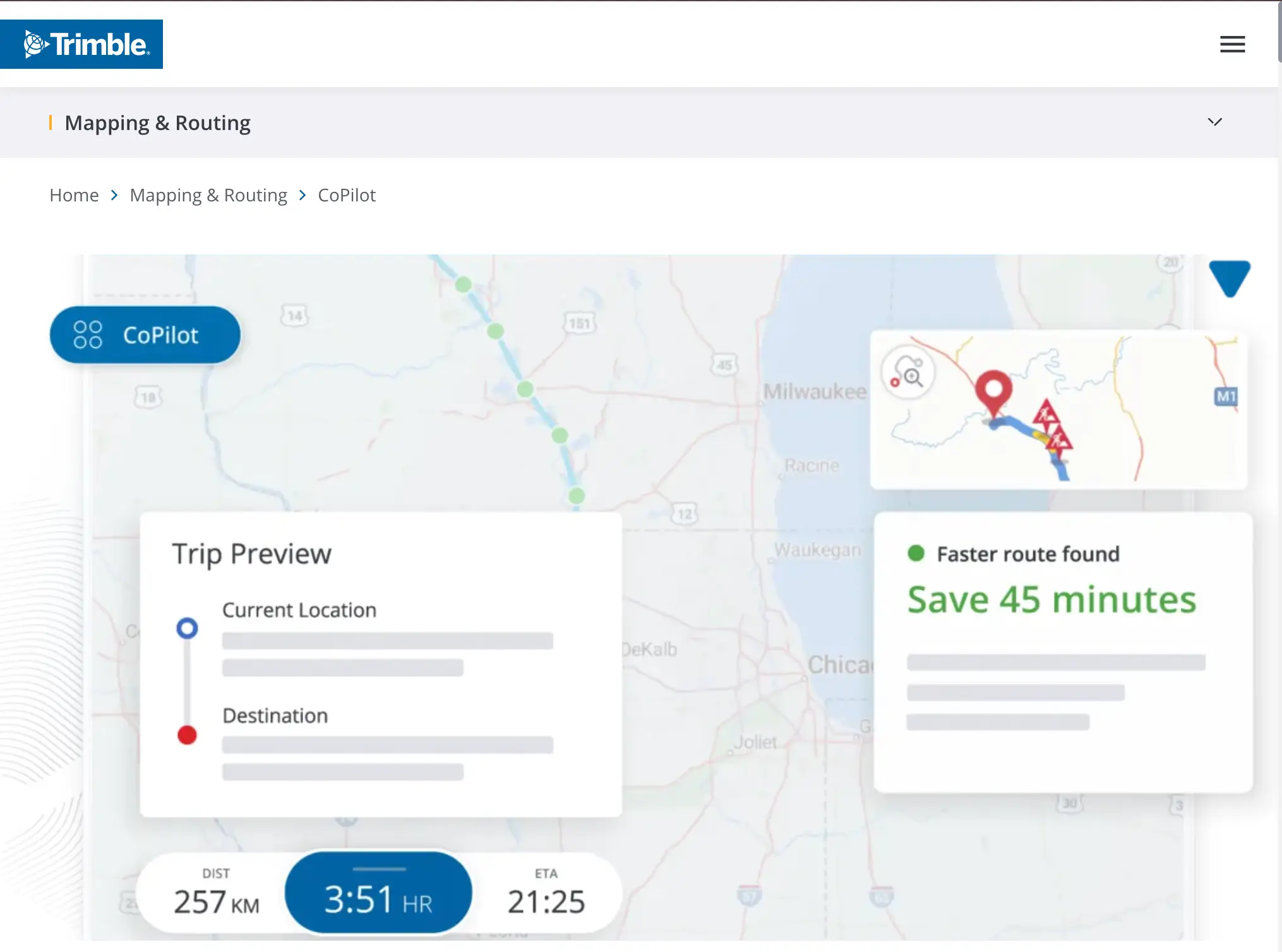
7. CoPilot GPS
Best for: Truck, RV, and large vehicle routing | Price: Free (premium paid) | Platforms: iOS, Android
CoPilot GPS is specifically designed for professional drivers and larger vehicles. It offers customizable routes based on vehicle type — car, RV, or truck — taking road width, height clearance, and weight restrictions into account. This makes it essential for delivery businesses operating box trucks or vans that can't safely navigate all the routes a car could handle.
CoPilot supports up to 52 stops per route, provides three alternate route options with time and distance details for each, and offers comprehensive offline maps. Its premium version includes voice-guided navigation, 3D maps, and live traffic updates. For businesses with larger delivery vehicles, CoPilot solves a problem that general navigation apps simply ignore.
8. MAPS.ME
Best for: Lightweight offline maps with minimal battery drain | Price: Free | Platforms: iOS, Android
MAPS.ME is built around one core strength: fast, detailed offline maps that consume minimal battery and storage. Powered by OpenStreetMap data, it provides worldwide offline navigation with turn-by-turn directions, bookmarks, POI search, and voice guidance — all without needing an internet connection.
Its lightweight design makes it especially practical for extended delivery shifts where battery life matters, or for international operations where data roaming isn't an option. Route recalculation after a missed turn can be slower than competitors, but for drivers who prioritize reliability and simplicity over flashy features, MAPS.ME is a strong choice.
9. OsmAnd
Best for: Maximum customization and open-source flexibility | Price: Free (premium paid) | Platforms: iOS, Android
OsmAnd is the power-user's navigation app. Also based on OpenStreetMap data, it offers extensive customization options: lane guidance, speed limits, bike paths, elevation data, custom map layers, and configurable routing preferences. You can download offline maps at multiple detail levels and configure the app to behave exactly how you want.
For delivery businesses that need precise, customizable navigation data — or operate in areas where commercial map data is sparse but OpenStreetMap coverage is strong — OsmAnd provides a level of control that no mainstream app can match. The tradeoff is a steeper learning curve and a less polished interface compared to Google Maps or Waze.
Quick Comparison
Each app has a distinct sweet spot. Google Maps and Waze are the best all-rounders for daily driving and urban delivery. Apple Maps excels for iOS-only teams. Sygic, HERE WeGo, MAPS.ME, and OsmAnd are the strongest options for offline navigation. CoPilot is the clear choice for larger vehicles. And MapQuest remains a reliable, simple option for drivers who don't need advanced features.
All of these apps share one important limitation: they're designed for navigating individual routes, not for optimizing multi-stop delivery operations. They can tell a driver the best way to get from Stop A to Stop B, but they can't determine the most efficient order to visit 30 stops, balance workloads across multiple drivers, or adapt route sequences in real time based on changing delivery windows.
Navigation Apps vs. Route Optimization Software
For personal use or single-destination trips, the navigation apps above are all you need. But for delivery businesses, there's a critical gap between what a navigation app does and what your operation actually requires.
Navigation apps handle the how do I get there? question. Route optimization software handles the where should I go, in what order, and how do I fit everything into my delivery windows? question — which is a fundamentally harder problem with an exponentially larger impact on your costs and efficiency.
Tools like EasyRoutes bridge this gap. EasyRoutes pulls your Shopify orders automatically, optimizes stop sequence using AI algorithms, splits orders across multiple drivers, and dispatches routes to the EasyRoutes driver app — which then hands off turn-by-turn navigation to your preferred navigation app (Google Maps, Waze, or Apple Maps). You get the best of both worlds: intelligent route optimization from EasyRoutes and familiar, reliable navigation from whichever app your drivers already know and trust.
It depends on what you need. Waze is generally better for real-time traffic avoidance and community-sourced road alerts, making it the stronger choice for drivers who want to dodge congestion. Google Maps is more versatile overall, with better support for public transit, walking, cycling, business information, and offline maps. Many delivery drivers use both — Google Maps for planning and general navigation, Waze for the actual drive when traffic is a concern.
Is Apple Maps good enough for deliveries?
In 2026, Apple Maps has closed much of the gap with Google Maps. Its routing accuracy, real-time traffic data, and urban mapping are now strong enough for professional delivery use. The main limitation is that it's iOS-only, so teams with mixed device types can't standardize on it. If your entire team uses iPhones, Apple Maps is a solid choice.
Which navigation app works best offline?
HERE WeGo, Sygic, MAPS.ME, and OsmAnd all offer robust offline navigation. HERE WeGo is the most user-friendly for offline use, Sygic offers the richest feature set, MAPS.ME is the lightest on battery, and OsmAnd offers the most customization. For delivery drivers working in areas with spotty coverage, any of these four will keep you on track.
Can I use a navigation app for multi-stop delivery routes?
Most navigation apps support a limited number of stops (Google Maps caps at 10), and none of them optimize stop order — they simply route your stops in the sequence you enter them. For multi-stop delivery routes, you need dedicated route optimization software like EasyRoutes to determine the most efficient sequence, then hand off navigation to your preferred app.
Conclusion
The best navigation app for you depends on your priorities: Google Maps for all-around reliability, Waze for traffic avoidance, Apple Maps for iOS integration, Sygic for premium offline features, HERE WeGo for offline simplicity, CoPilot for large vehicles, and MAPS.ME or OsmAnd for lightweight open-source offline maps.
For delivery businesses, the real power comes from combining a great navigation app with purpose-built route optimization. Let EasyRoutes figure out the optimal route, then let your favourite navigation app guide you there.
Ready to go beyond basic navigation? EasyRoutes optimizes delivery routes with your store's orders automatically, then hands off turn-by-turn directions to Google Maps, Waze, or Apple Maps. Start your 14-day free trial today.
About EasyRoutes
EasyRoutes is the AI-native delivery operations platform trusted by 5,000+ businesses across 75+ countries. Plan routes in seconds, dispatch drivers automatically, and delight your customers — from Shopify or any order source. Experience delivery operations that run themselves. Rated 4.8 stars and certified Built for Shopify.